Wednesday, August 31, 2016

Warren Point


Last time I was here in 2008, my wife waited in the car in Greencastle Golf Club Carpark while I scooted down to the 12th Green to take a quick shot of the light and back. This time things were a lot more leisurely. The Golf Course lies along the coast just north of Greencastle itself. I asked in the clubhouse could I take a photo or two of the light and they said there was no problem - just be very careful of people driving off the 12th tee! Its not far from the Clubhouse - a five minute walk.


"1861. Active; focal plane 9 m (30 ft); white flash every 1.5 s. 8 m (27 ft) round cylindrical brick tower with lantern, painted white with green trim" to quote the Lighthouse Directory and who am I to argue? Back in 1870 it exhibited a fixed red light apparently.


The photos above and below were taken from Magilligan Point on the other side of the Foyle.


Glenburnie


A red pile structure on Lough Foyle. It looks pretty close to the Moville light when viewed from Moville quay but probably isn't. This picture was taken into the morning sun, so the detail is missing.
 55° 10.4´ N 7° 01.6´ W Oc.R. period 6s. It is 10 ft above high tide and has a range of 3nm.

Moville Revisited


Eight years since I was here last, I have always liked the Moville light. Very neat and tidy and orderly and of course fairly historic too. Its only about 600 yards off shore. Just drive into Moville and take any of the side streets heading to the shore and its readily visible. Built in 1882, this was the largest of a series of pile lights that guided ships down the Foyle to Derry, or Londonderry, whichever way you like to call it. 


The Eiffel Tower of Moville, as it has been called is 13 metres high and flashes once every 2.5 seconds with a range of four miles. A red sector covers Moville Bank inshore. It was built in 1882 and underwent restoration work in 2008


For a long time now, there has been disagreement between the British and Irish governments about the River Foyle. The British claim all the water as their own. The Irish dispute this. The River is therefore managed by a joint body set up especially for the purpose.


Long distance view from Magilligan Point looking south-westerly.

Tuesday, August 30, 2016

Whitecastle Light


Okay, this one is pure conjecture on my part. An 1877 official Admiralty booklet by Richard Hoskyn RN, entitled Sailing Directions for the Coast of Ireland, shows that the River Foyle was well lit with lighthouses, pile lights and a fishing smack. Over time, most of these have been replaced. Moville is the only pile light left in Ulster, with an abundance of pole lights (as the single structure above) lining the two banks of the Foyle. The light above is called Whitecastle after the townland of that name on the western shore, just north of Quigley's Point. But what of the eight poles sticking up out of the water next to it. Does that not look like the remains of a pile light? 


The above publication lists a pile light at Whitecastle  - "Whitecastle Lighthouse, on piles and painted black,lies on the south-east side of the channel off White Castle and exhibits a fixed white light at an elevation of  26 feet." Another 1870 publication, says this light was erected in 1848.
Of course, there may be a better explanation and I can't quite figure out why they would half-demolish a pile light but for now, I rest my case, m'lud.


 PS - I had originally listed this post as being the Redcastle Light. When it was pointed out that Trabas had a similar picture of the Whitecastle light, I double-checked and found I was wrong. The Redcastle Light lay about a mile further north and was painted red, not black. Sadly there is nothing left above the surface of the water anyway!

Culmore Point


Culmore Point Light beacon is a green round tower with a black base that stands at the entrance to Culmore Bay and the River Foyle. A light was established here in 1848 and the current structure dates from the 1920s. And it is one of the few lighthouses I have come across that is conspicuously marked with its night, in case it should be misplaced, I assume. It consists of a 23 ft conical tower painted white with a green base and stands next to Culmore Fort. One would imagine that local residents 50 years ago would have found the spot idyllic but the aesthetic beauty of the spot has been somewhat marred by the modern and necessary but rather ugly Londonderry Docks across the river and a bloody great pylon .


Like Ballynagard, the light itself was formerly displayed through the opening near the top of the structure but sadly this light is no longer active. The lighthouse here has been replaced by a functional nonentity a few metres away (see photo at the bottom of page)


The original 1848 light here consisted on a mast on top of a wooden box, displaying a fixed light


Son of Culmore Light

Brook Hall Light


Another light visible from Otterbank Road on the east side of the River Foyle is Brook Hall Light, so named because it stands adjacent to Brook Hall on the west side of the river. It is a white 20ft tower on a green base and has a quick flashing green light which has a range of 3 nautical miles.


The first light here was erected in 1859. It was a red brick tower exhibiting a fixed light.


Otterbank Light


Not listed in Russ Rowlett's Lighthouse Directory, the Otterbank (or Otter Bank) Light lies some 200m upriver from the Ballynagard Light (previous post) It marks the eastern side of the channel leading into Derry City. The light is a flashing red with a period of 4 seconds and stands some 20ft tall. 55° 01.9´ N 7° 16.6´ W


Photos taken from Otterbank Road on the east side of the river.

Ballynagard Lighthouse


From the Port Road, Derry

A lot of poring over Google maps beforehand convinced me that Ballynagard Lighthouse and other lights at Otterbank and Brook Hall were best viewed from the east side of the River Foyle. The light was originally exhibited through a window near the top of the structure but that seems to be blocked off now, replaced by a solar powered light on top of it.


Focal plane 6 m (20 ft); white flash every 3 s. 7 m (23 ft) concrete tower  Lighthouse painted white with a green base. It has a range of 3 nautical miles


From Otterbank Road, Derry


From Culmore Point Lighthouse downriver

Magilligan Point Light


This rather dilapidated-looking Pile Light is situated off Magilligan Point at the eastern entrance to the River Foyle, reached from Castlerock (previous entry) by a very scenic drive which is spoiled somewhat 0.5 miles from the Point by the appearance of the completely unattractive Magilligan Prison.


There is a Martello Tower at the point, a pub and a few holiday homes. There are views of Inishowen Head Lighthouse, Warren Point and Moville, all on or near the far coast in the Republic.
The light itself is Q.R. 7m 4M and marks the eastern extremity of the navigable channel through the entrance of the Foyle. 55° 11.730´N, 006° 58.055´W

River Bann Leading Lights


Front and rear leading lights

About a quarter of a mile upriver from the entrance to the Bann at Barmouth lies the first of the leading lights that mark the correct approach for vessels heading inland to Coleraine. The front light is situated on the shore, while the rear light sits nestled a further 300 yards south east among the gorse of the dunes. Reaching the front light from the pier involves walking over a couple of easyish dunes and then a short walk along the small beach. 


The front light is a five meter high white pyramid metal tower Oc 5s 6m 2M sitting on a stone plinth. The light itself is 6m above sea level.


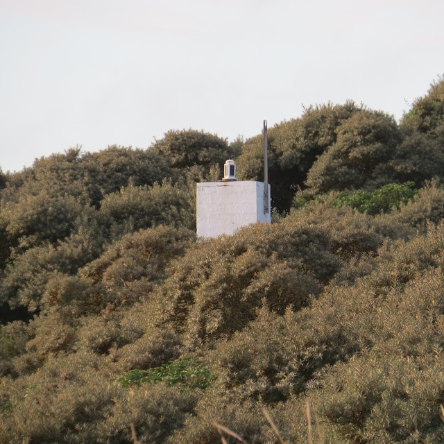
The rear light is a white square concrete tower, its light sitting 14 meters above sea level. Oc 5s 14m 2M  Position 55° 9.869' N 006° 46.173' W


Chart from In Your Footsteps showing how the two lights combine to guide incoming traffic past the entrance to the Bann


The Bann is well served by port and starboard markers

Barmouth West Pierhead


In contrast to the substantial light on the east pier of the entrance to the Bann, the west pier is served by two extremely rusty poles, one at the very end of the stone pier, the other twenty yards behind it. Both are suffering greatly from neglect. The one further back (ie, on the right in the picture above) is the main light and it was apparently once green in colour. Its light is Fl R 5s 6m 2M


West pier light with East pier light in the distance


Barmouth East Pierhead


About two miles west of Portstewart Point, lies the entrance of the River Bann, which is the longest river in Ulster, its length, Lower and Upper and Bann combined, is 129 km or 80 miles. Exiting into the Atlantic at Barmouth, on the north coast, the river winds its way from its source in the Mourne Mountains, situated in the southeast corner of Northern Ireland, pausing in the middle to widen into the enormous Lough Neagh. Incidentally, the name Barmouth doesn't appear on Google maps. 


Although only 2 miles away, three quarters of that distance is made up of the magnificent Portstewart Strand and so, rather than a 3.5 mile trek over soft sand, it appeared on the map that driving to Castlerock on the west side of the Bann entrance, would necessitate a mere 0.5 mile trek over sand. Of course the 28 minute drive back to Coleraine and then back out to the coast had to be factored in but it still seemed the better bet. Of course by doing this I would be on the wrong side of the river for the East Pier Light but it was easily visible from the West Pier.
Despite dire warnings of soft sand, it appears I could easily have driven up to the pier across the strand but it didn't seem right to disturb the hardy dog-walkers (it was 7.30am on a Bank Holiday Sunday) so I parked up and walked.  And I'm glad I did. It was a lovely morning and quite idyllic.


The east pierhead has a 4.5 metre high white four-sided, tapering concrete tower. It's light is, reputedly, Fl R 5s 6m 2M . I believe it is operated by the Coleraine Port Authority. Originally oil-lit, it was constructed in 1947. This lamp was replaced with a battery-powered one in 1952 (and latterly with a solar-powered one). (see here page 64 for construction of moles and lights)


The entrance to the Bann

Monday, August 29, 2016

Portstewart Point


That rare thing, a free day all to myself, so I decided to do a blitz of lighthouse and other lights on the north coast of this beautiful island of ours. An early start to maximise the day, meant I was on the road at 4am, and driving up to this little beauty in Portstewart just after 7am. 
Its address is the Atlantic Circle and I found it fairly easy. There's really only one main road leading into Portstewart, with new-built apartments on the right hand side. At what feels like the centre of the town, one road branches upwards to the left and one road leads downwards to the right. Take the latter, you come to the sea and turn left. 


Looks like its been freshly painted. It could have been an ice-cream kiosk in another life.


The technical stuff - it exhibits a flashing red light every 10 seconds (7 seconds on, three seconds off) and has a focal plane of 21m. The mast carries pilot signals and the light is exhibited at the base of the mast.
Latitude / Longitude: 55.18877° / -6.721036°


The lick of paint means that it looks a lot better than in Ewan McGregor's 2009 photo


My first visit to Portstewart. First and fleeting impressions were very favourable. A lot of new apartments overlooking the sea and of course they have a famous golf course here. And not many Union Jacks in evidence, which I know is really only an expression of identity but, to us in the south, always comes across as a bit intimidating.